

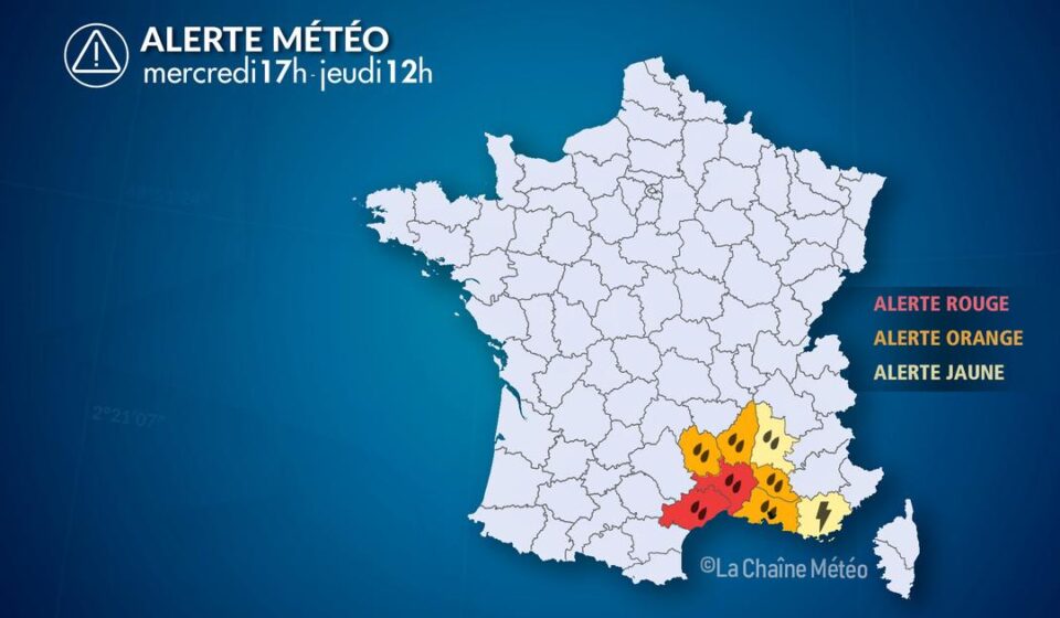

A Mediterranean episode of rain and thunderstorms has been affecting Languedoc and the Cévennes since Wednesday, September 30, 2026. At 5:45 p.m., the intense and sometimes stationary rains are affecting, in particular, the Hérault and the Gard; the risk of runoff and flash floods remains high until Thursday, October 1.
What is planned
The storms have been fueled by humid air from the Mediterranean, bringing increased rainfall to the Cévennes mountains and their foothills. Wednesday evening and overnight, they are expected to persist over the Gard and Hérault departments, before moving towards or affecting the coast. On Thursday, thunderstorms are still forecast for the area, before gradually shifting towards Provence and the Var department.
In its report published on September 30, Météo-France indicated rainfall totals of 250 to 350 mm for the event in the Cévennes mountains, locally reaching up to 400 mm. In the plains, rainfall could reach 100 to 200 mm over a wide area, with locally higher amounts. These are forecast estimates: the actual amounts received will vary depending on the path and persistence of the storm cells. ( meteofrance.com )
At 5 p.m., the weather forecast from La Chaîne Météo (The Weather Channel) already reported significant rainfall totals: 337.6 mm in Saint-Hippolyte-du-Fort, 299 mm in Colognac, 262.1 mm in Prades-le-Lez, and 203.5 mm in Le Vigan. These observations should not be confused with the total rainfall still expected for the remainder of the weather event.
The areas concerned
The most exposed areas are in the Cévennes mountains, the foothills, and the plains of the Hérault and Gard departments, particularly around Montpellier and Nîmes. Thunderstorms may also affect the Bouches-du-Rhône department and, later on Thursday, the Vaucluse and Var departments. The intensity of the rainfall over a short period could cause water to accumulate in urban areas, leading to runoff and rapid rises in small streams.
The weather channel reported at 5:45 PM that heavy and persistent rain was still falling between Montpellier and Nîmes. It also indicated a significant rise in the Lez River. These are observations reported at that time, and not a forecast that is uniformly valid for all municipalities.
The level of vigilance
In its bulletin issued Wednesday, September 30 at 4:03 p.m., Météo-France placed the Gard department under red alert for heavy rain and flooding, and the Hérault department under red alert for heavy rain and flooding. Thunderstorms were under orange alert in both departments; the Bouches-du-Rhône department was under orange alert for heavy rain and flooding. For Thursday, October 1, the alert forecast maintained the Hérault department under red alert for flooding, while the Gard and Hérault departments were under orange alert for heavy rain and flooding. These levels may change: it is advisable to consult the official updates. ( vigilance.meteofrance.fr )
The Vigicrues weather alert system for « rain and flooding » and for « floods » are two separate systems. Météo-France also indicates the Lez River is under a red flood alert in its territorial monitoring; this level applies to the monitored section and does not mean that all waterways in the Hérault department are at the same level. ( vigicrues.gouv.fr )
Precautions to know
- Limit your travel and stay informed of the instructions from the authorities.
- Do not use a submerged road, even if the water seems shallow; also avoid fording streams.
- Stay away from waterways, bridges and low-lying areas. Do not go down into parking lots or basements prone to flooding.
- Under red alert, Météo-France recommends staying home, not using your car, and only evacuating if ordered to do so by the authorities. ( vigilance.meteofrance.fr )
Source: Weather RSS Feed: The latest weather information with the RSS Feed – The Weather Channel. Alerts verified with Météo-France; river conditions consulted on Vigicrues.
Original article: See the original source