
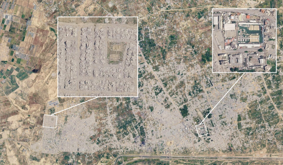

New Google Earth views of the southern Gaza Strip show the extent of the destruction in Rafah. Taken on February 25, 2026, and made available on the platform on September 27, they reveal residential neighborhoods and agricultural areas that have been significantly transformed since the last available images, which dated from June 2024.
Two years apart between the images
The comparison contrasts a snapshot from June 3, 2024 with another from February 25, 2026. Between these two dates, the urban landscapes of Rafah have been profoundly transformed: many buildings have disappeared, roads are covered with debris, and the greenhouses visible to the north of the city have been largely destroyed.
The February images were already available in the software version of Google Earth since May 2026. However, their recent release on the platform broadens their accessibility to the general public. They do not constitute a real-time survey: they show the state of the area nearly seven months before their publication.
Satellite imagery specialist Jamon Van den Hoek, a professor at Oregon State University, estimates that large portions of Rafah show a level of destruction close to total. With his colleague Corey Scher, he is monitoring and documenting the damage in the Gaza Strip. The images notably show the former refugee camp of Tel al-Sultan, where more than 20,000 people lived before the war.
Homes and farmland affected
The destruction also affects agricultural infrastructure. The greenhouses and cultivated plots north of Rafah, still visible in the images from June 2024, have largely disappeared in those from February 2026. In March 2025, an analysis based on data from researcher He Yin had already estimated that nearly two-thirds of Gaza’s greenhouses had been destroyed.
Not everything has been razed. Public buildings and large apartment blocks are still visible, including a branch of Al-Quds Open University and the Rafah municipal stadium. Images show vehicles and tents identified as military near some of these sites. According to reports from France 24, the Israeli army and allied armed groups are operating in this area, which has been largely emptied of its residents.
A city evacuated, then further destruction
The sequence begins with the Israeli offensive launched against Rafah in May 2024, accompanied by evacuation orders that led to the departure of hundreds of thousands of residents. After a ceasefire began on January 19, 2025, and Israeli forces withdrew from certain areas, the offensive resumed on March 20. On March 31, the army ordered the population to leave the city for al-Mawasi.
Rafah had approximately 250,000 inhabitants and also hosted 1.5 million people displaced by the war, according to figures cited in the report. A map created by Corey Scher and Jamon Van den Hoek using satellite data shows that many buildings damaged once were damaged again between March and October 2025, particularly in the Rafah metropolitan area.
Khalil Sayegh, a researcher and political analyst from Gaza, links the acceleration of the demolitions after March 31, 2025, to the use of private contractors equipped with bulldozers. The Israeli army, for its part, claims that the demolitions targeted Hamas hideouts and tunnels. Journalistic investigations mentioned in the report offer another interpretation: they suggest that the scale of the demolitions could also be part of the creation of a buffer zone. This objective remains an analysis, and not a fact established by the images alone.
Incomplete satellite coverage
The Google Earth update does not cover the entire Gaza Strip. The most recently available images of the south date from February 2026; those of the central area, from January. For the north, the platform still displays images from 2024 or 2025.
Higher-quality images of northern Gaza, taken in 2025, were briefly accessible on the Israeli public mapping portal Govmap. A copy preserved by cartographer Nathan Ruser reveals at least three fortified military bases east of Gaza City, complete with tents and vehicles. These installations do not appear in older Google Earth images.
Author: Nathan GALLO
Source: France 24 – News & current events – Live international news (www.france24.com)
Original article: See the original source